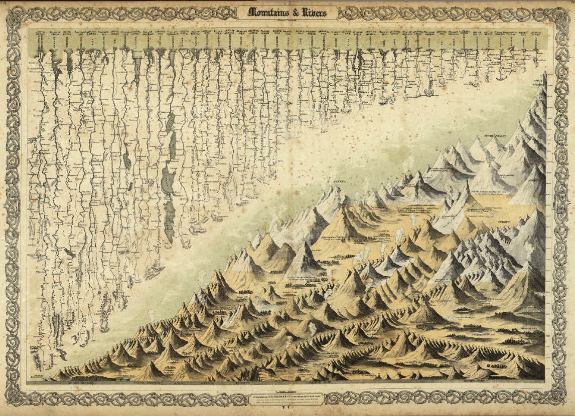
Mountains and Rivers
I’m delaying the third post on deltaic physical environments (the other two are here and here) to briefly write about a map I recently came across at Big Map Blog (which you absolutely should follow, by the way).

Produced by George Colton in 1856, the map depicts, left to right, several dozen major world rivers decreasing in length and several hundred mountains increasing in size.
Be sure to click the image above for a super high-resolution, deep-zoom version.
Although the map completely abstracts individual rivers from their particular uplands, I still love the way its arrangement of features implies the massive redistribution of sediment that takes place in large watersheds.
Of course, not all the rivers shown here end in deltas. Sometimes tides, waves, sediment loads, and the physical features of both the river and the body of water into which it drains all combine to prevent land from accreting at a river mouth, forming an estuary instead.
But even though such kinds of conditions might not allow for land-building, rest assured that each river depicted on this map is diligently transporting bits and pieces of its uplands down to its mouth. The Alabama/Mobile/Tombigbee, for example, ends in an estuary rather than a delta, but it still discharges 4.5 million tons of sediment into Mobile Bay each year. And it’s one of the smaller rivers show here (in the right third of the image).
Additionally, Colton’s map documents not only the diversity of deltaic landforms around the world, but also suggests just how many deltas have in fact been historically important sites of human occupation. Moving from left to right on the map, the Mississippi, Yangtze, Ganges and Brahmaputra (“Burrampooter” according to Colton), Niger, Tigris and Euphrates, Indus, and Rhine river deltas—to name just a handful—have all supported major population centers, some of which are thousands of years old.
And finally, I’d say that the map is just great for exploring. Zoom right in and you’ll find glaciers, active volcanos, major architectural and natural landmarks, and even some traces of Alexander von Humboldt’s Latin American expedition.
There are a lot more wonderful, super high-resolution thematic maps like this one available through both Big Map Blog and David Rumsey’s Map Collection. Be sure to check both sites out for similar treasures, regardless of your field/subject of interest.

4 Comments
Join the discussion and tell us your opinion.
It’s interesting that, even as he decided to stretch out every river into a general straightness, Colton kept a certain skeuomorphic squiggliness at the smaller scale. He also textually annotates the proper geographic compass direction along each stretch of river. It’s a neat compromise between topological and topographic faithfulness, and reminds me, by comparison, of the “subway map” diagrams of river systems found here:
http://somethingaboutmaps.wordpress.com/river-maps/
Hehe. Yep! I’d noticed the way he preserved compass directions, but had decided to let folks discover that for themselves. Also: you know that those river maps are by our own Daniel Huffman, right? He finished his cartography MS a year ago or so, but he’s still always in the cart lab. Go chat with him if you haven’t. And if we’re talking about straightening rivers, we should probably mention *ahem* a certain straightened Madison map, n’est-ce pas? http://viewshed.matinic.us/2012/02/23/321/
Wasn’t aware that those river maps were from one of our own! (I also didn’t realize until pretty recently that Bostonography was Tim Wallace’s shop…)
[…] few posts back, I flagged an 1856 map showing major mountains and rivers of the world arranged by size. One of the reasons I like that […]